NAV-003 - Protection Of The Great Barrier Reef Region And The Torres Strait-Compulsory Pilotage Requirement
22 August 2020
Marine Notice 07/20
TO: | ALL SHIPOWNERS, OPERATORS, MASTERS AND OFFICERS OF MERCHANT SHIPS, AND AUTHORIZED CLASSIFICATION SOCIETIES |
SUBJECT: | Protection of the Great Barrier Reef Region and the Torres Strait - Compulsory Pilotage Requirement |
Reference: |
|
NAV-003
Supersedes: Marine Notice NAV-003, dated 06/2012,
The following changes have been included:
It updates contact and website information.
PURPOSE:
This Marine Notice advises those involved with the operation and navigation of Liberian vessels of the action taken by the International Maritime Organization and the Commonwealth of Australia toward minimizing the risk of vessel source pollution in The Great Barrier Reef Region and the Torres Strait through the implementation of voluntary and compulsory pilotage schemes.
APPLICABILITY:
Under the Great Barrier Reef Marine Park Amendment Act of 1991, enacted by the Australian Parliament, and also provided by Ref. (d) ships of 70 metres in length and over, as well as all oil tankers, chemical tankers, and gas carriers, irrespective of size operating within the areas of The Great Barrier Reef and the Torres Strait are regulated.
REQUIREMENTS:
1.0 Compulsory Pilotage
1.1 Great Barrier Reef Pilotage Area
Inquiries concerning the subject of this Notice should be directed to the Office of the Deputy Commissioner, Republic of
Liberia, the Liberian International Ship & Corporate Registry, 22980 Indian Creek Drive., Suite 200, Dulles, VA 20166,
USA. The most current version of all Marine Notices are available in the Online Library at: http://www.liscr.com
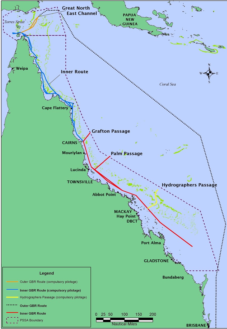
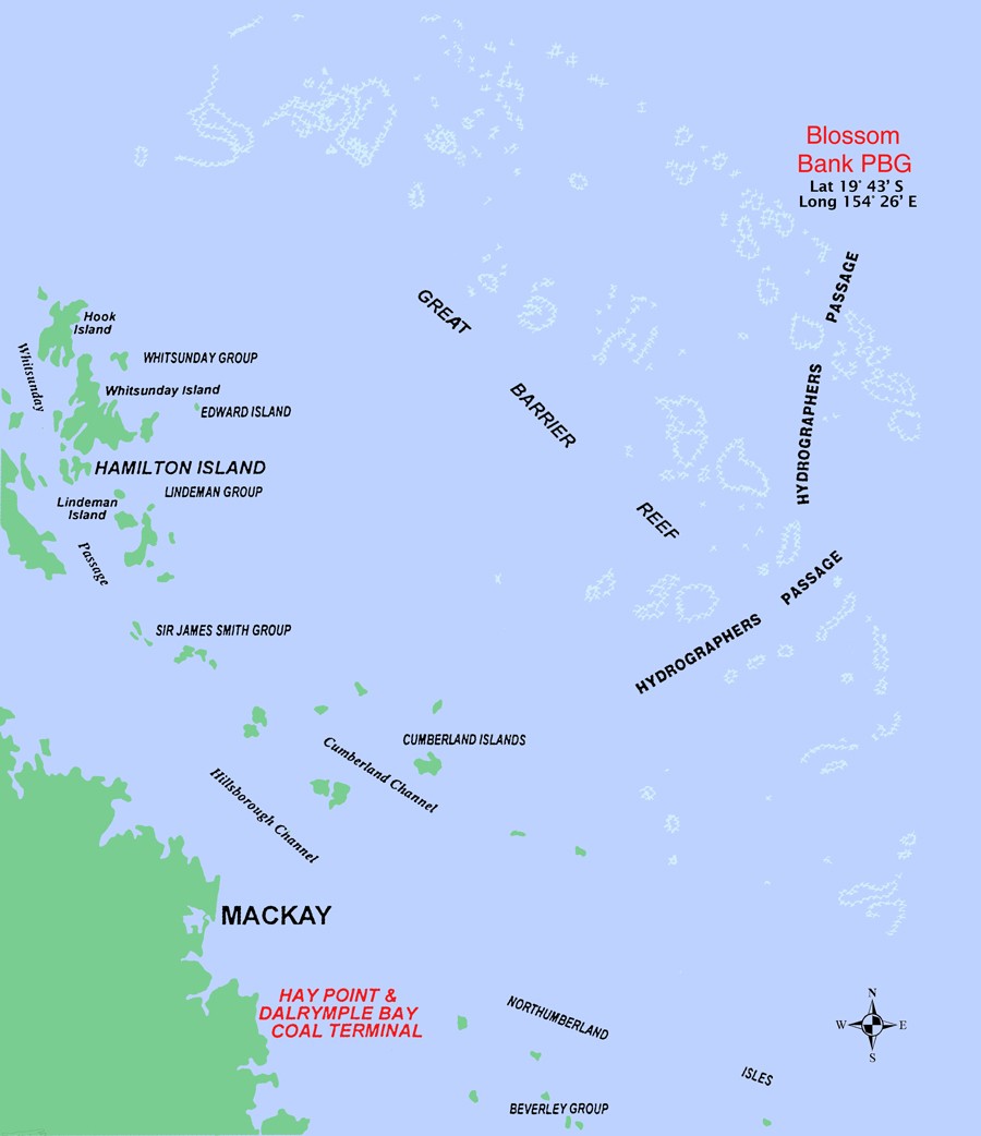
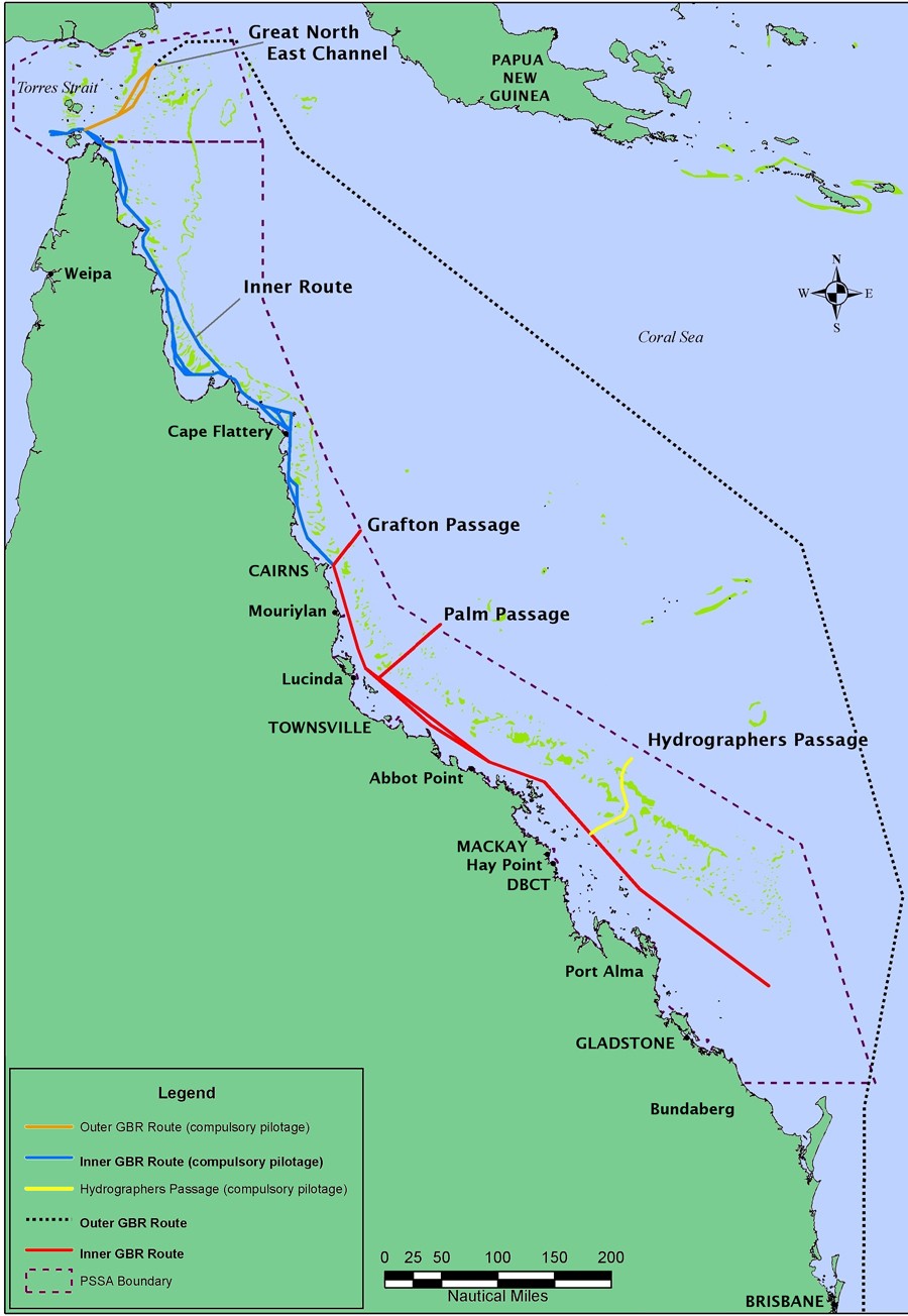
.1 The Great Barrier Reef between the northern extreme of Cape York Peninsula (10º 041´ South) and the vicinity of Cairns Roads (16º 40´ South); and in Hydrographer’s Passage.
.2 All ships of 70 metres in length and over, as well as all oil tankers, chemical tankers, and liquefied gas carriers, irrespective of size must have a pilot onboard.
1.2 Torres Strait Pilotage Area
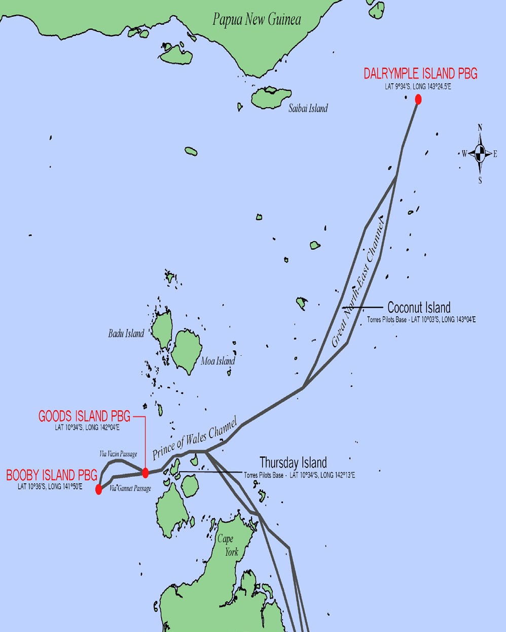
.1 The Torres Strait Pilotage Area is bound on the south by the line of latitude (10º 41’ South), and on the north by Australia’s EEZ, and divided into the following two parts:
.1 Torres Strait Pilotage Area A is bound by the longitudes (141º 50´ East and 142º 05´ East).
.2 Torres Strait Pilotage Area B is bound by the longitudes 142º 05´ East and 143º 24´ East).
.2 All vessels of 70 metres or more in overall length, and all tankers, chemical tankers and liquefied gas carriers, except defense force vessels, when transiting through Torres Strait Pilotage Area A with a draught of 8 metres or more must have a pilot onboard.
.3 All vessels (irrespective of draft) of 70 metres or more in overall length, and all tankers, chemical tankers and liquefied gas carriers, except defense force vessels, when transiting through Torres Strait Pilotage Area B must have a pilot on board.
.4 Further details regarding Torres Strait pilotage requirements can be found at:
https://torrespilots.com.au/pilot-information/
2.0 Areas to Avoid
Furthermore, being aware of the close relationship between the safety of navigation and the prevention of pollution from ships, and recalling the recent Amendment to the General Provisions on Ships' Routing, which states that Ships' Routing may be used to reduce the risk of pollution caused by ships colliding or grounding in or near environmentally sensitive areas; navigators are reminded that the Capricornia Section of the Great Barrier Reef Marine Park is designated in IMO Ships' Routing as an "AREA TO BE AVOIDED" (Part D, page 11).
3.0 Additional Hazards
The Great Barrier Reef Region of Australia contains a scattered maze of submerged shoals and reefs. Added to these hazards are the strong trade winds and occasional cyclones that are indicative of the region. When all of these factors are combined with intense fishing activity, peaking from April to October, the result is a significant obstacle to the safe navigation of a vessel.
4.0 Administration Requirements
In light of this, the Office of the Deputy Commissioner requires the following from the vessels in its registry:
.1 Absolute compliance with the Australian Pilotage Requirements;
.2 Regular use of properly licensed pilots in those areas where it is specified that pilotage is necessary; and
.3 The use of sound judgment and caution when navigating in or near this particularly sensitive area.
5.0 Additional Information
The Australian Maritime Safety Authority recently released a new publication entitled "Reef Guide - A Shipmaster's Handbook to the Torres Strait and the Great Barrier Reef". The booklet could be of invaluable assistance for mariners navigating through these areas.
Mariners, ship owners and operators are encouraged to obtain copies from the following offices:
Maritime Division Navigational Services
Queensland Transport Australian Maritime Safety Authority
MacArthur Avenue East G. P.O. Box 2181
Pinkenba Queensland 4008 Canberra City ACT 2601
Australia Australia
Phone: +61 7 3632 7500z Phone: +61 6279 5000
brisbane.maritime@msq.qld.gov.au Fax: +61 6279 55858
Or visit Australian Maritime Safety Authority website at:
* * * * *
ANNEX Compulsory Pilotage Chart
Torres Strait and Great Northeast Channel Chart
Hydrographers Passage Chart
Compulsory Pilotage Chart
Reef VTS Reporting Chart