
Marine Operations Note: 06/2021 - Main Public Routes along the Coast of Zhejiang, People’s Republic of China
03 November 2021
Marine Operation Note 06/2021
November 3, 2021
Marine Operations Note: 06/2021
Subject: Main Public Routes along the Coast of Zhejiang, People’s Republic of China
Reference: a) Maritime Traffic Safety Law of the People’s Republic of China b) Public Notice on the Adjustment of Main Public Shipping Routes along the Coast of Zhejiang Province
To: All Vessel Owners, Operators and Masters of Liberian Flagged Vessels
A. Purpose
The purpose of this Note is to draw attention to a Public Notice issued by Zhejiang Maritime Safety Administration on August 30, 2021 on the adjustment of fifteen (15) main sea routes along Coast of Zhejiang Province. The adjustment was formally implemented from September 10, 2021.
The adjustments of sea routes are expected to be helpful to establish clear borderlines between vessels’ routes and fishing areas, and reduce the risk of collision between commercial and fishing vessels. Upon optimization and adjustment, the routes are seen in the pattern of three (3) vertical and six (6) horizontal routes. The adjustments concluded with three (3) vertical and six (6) horizontal routes.
B. Adjusted Routes
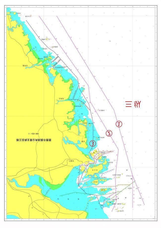
From East to West, the three (3) vertical routes, shown in the figure below, consist of:
- Outer Route: Main shipping route of the North-South Channel along the coast of China. The route primarily serves large ships, usually greater than 10,000 tons sailing in the north-south direction.
- East Route: Located between the Outer Route and the West Route, it runs through the coast of Zhejiang Province from north to south. It primarily serves vessels entering and leaving the Yangtze River and ships of about 10,000 tons sailing on the north-south route.
- West Route: It is the innermost of the three (3) vertical routs. It is closer to the coast and islands, and mainly serves small and medium-sized ships of 5,000 tons and below.
Six (6) horizontal routes are the main channels for vessels entering and leaving Zhejiang ports from the direction of East to West. They are composed of the entry and exit routes in six (6) areas with numerous ports: Northern Zhoushan, Central and Northern Zhoushan, Central Zhoushan, Core port area of Ningbo-Zhoushan Port, Taizhou Bay, Wenzhou Port and Yueqing Bay from North to South.
C. Exercise Caution
- The route width is the theoretical width. The waterway may be restricted by natural environment and navigation conditions and should be limited to the actual width of the navigable water area.
- The route should be selected based on the characteristics of the ship and the port of destination. For large ships passing through the coastal areas of Zhejiang, it is recommended to choose the outer route and pass through the east side of the Haijiao.
- The ship should maintain a proper lookout, keep the AIS in good working condition and a listening watch on VHF, and switch to the watch-keeping channel in time after entering the VTS area. If the AIS is not working, please refer to section 4 of Marine Operations Note: 05/2021.
- Particular caution should be taken when entering and leaving the fairway, passing through the high traffic density and the traffic crossing area. When crossing the fairway, the ship should cross on a heading as nearly as practicable at right angles to the general direction of traffic flow.
- The vessel shall avoid anchoring and operating in the fairway waters.
- In case of any danger, the ship should report to the Maritime Safety Administration in a timely manner.
For additional information, please refer to the attached Circular Ref. No.: PNI [2021] 12 by HUATAI
INSURANCE AGENCY & CONSULTANT SERVICE LTD.
If you have any questions, please contact our Fleet Performance Department at Telephone: +1-703-790-3434 or by email to prevention@liscr.com.
* * * * *
Circular Ref. No.: PNI [2021] 12
Date: 8 September 2021

Coastal Waters of Zhejiang Province, China - Public Notice on the Adjustment of Main Public Shipping Routes
I. General Information of the Public Notice
According to the relevant provisions of Maritime Traffic Safety Law of the People’s Republic of China, Zhejiang Maritime Safety Administration issued the Public Notice on the Adjustment of Main Public Shipping Routes along Coast of Zhejiang Province on August 30, 2021, which will be formally implemented from September 10, 2021.
The adjustment of sea route will be helpful to establish a relatively clear borderline between ship’s routes and fishing areas, and reduce the potential risk of collision incidents between commercial vessels and fishing vessels.
II. Brief on the Public Notice and the Adjusted Routes
After optimization and adjustment, the 15 main shipping routes along the coast of Zhejiang are shown in the pattern of “three vertical and six horizontal routes”.
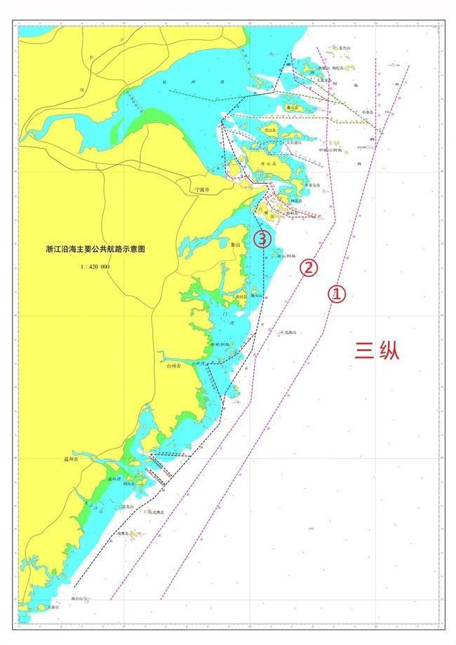
From east to west, the “three vertical routes” consists of “Outer Route, East Route and West Route”.
○1 Outer Route: It is the main shipping route of the North-South Channel along the coast of China, mainly serving large ships sailing in the north-south direction.
○2 East Route: Located between the Outer Route and the West Route, it runs through the coast of Zhejiang Province from north to south, mainly serving ships entering and leaving the Yangtze River and ships of about 10,000 tons sailing on the north-south route.
○3 West Route: It is located at the innermost side of the “three vertical”, close to the coast and islands, and mainly serves small and medium-sized ships of 5,000 tons and below.
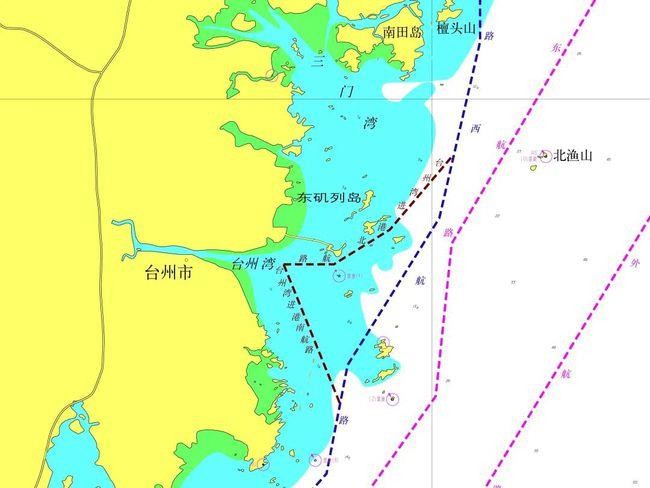
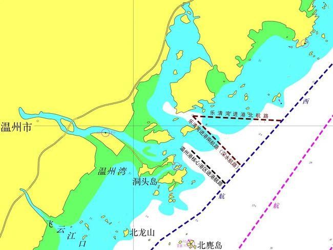
“Six horizontal routes” are the main channels for ships entering and leaving Zhejiang ports from the direction of east to west. They are composed of the entry and exit routes in six areas with numerous ports, namely, “Northern Zhoushan, Central and Northern Zhoushan, Central Zhoushan, Core port area of Ningbo-Zhoushan Port, Taizhou Bay, Wenzhou Port and Yueqing Bay” from north to south.
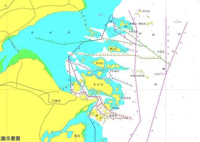
Among them, the route map of “Zhoushan, Central and Northern Zhoushan, Central Zhoushan, Core port area of Ningbo-Zhoushan Port” is illustrated as follows:
The route map of “Taizhou Bay” is illustrated as follows:
The route map of “Wenzhou Port and Yueqing Bay” is illustrated as follows:
III. Attention and Caution
- The route width is the theoretical width, and the waterway restricted by natural environment and navigation conditions, shall be limited to its actual width of the navigable water area.
- The ship shall select the route scientifically and reasonably according to the characteristics of the ship and the port of destination with reference to the latest navigation materials. For large ships passing through the coastal areas of Zhejiang, it is recommended to choose the outer route preferentially and pass through the east side of the Haijiao.
- The ship shall maintain a proper lookout, keep the equipment of AIS in good working condition and a listening watch on VHF, and switch to the watchkeeping channel in time after entering the VTS area.
- The ship shall proceed on the right side of the central line of the route at a safe speed and avoid parallel running with other ships for a long time with due regard to the observance of good seamanship. Particular caution shall be taken when entering and leaving the fairway, passing through the high traffic density and the traffic crossing area. When crossing the fairway, the ship shall cross on a heading as nearly as practicable at right angles to the general direction of traffic flow.
- The vessel shall avoid anchoring and operating in the fairway waters.
- In case of any danger, it shall be reported to the Maritime Safety Administration in time.
We hope the above is of assistance. Any query, please feel free to contact our local branches.
Best regards,
LUO Yong
General Manager
Appendix: Main Public Shipping Routes along Coast of Zhejiang Province
Appendix:
Main Public Shipping Routes along
Coast of Zhejiang Province
- Outer Route
No. | Coordinate of Central Line | Course (°) | Distance to the Next Waypoint (nm) | Route Width | |
Latitude (N) | Longitude (E) | ||||
1 | 30°44.00′ | 123°16.00′ | 202 | 36.76 | 3 nm on both sides of Central Line |
2 | 30°10.00′ | 123°00.00′ | 196 | 80.12 | |
3 | 28°53.00′ | 122°35.00′ | 211.5 | 132.20 | |
4 | 27°00.00′ | 121°17.50′ | / | / | |
- Outer Route Branch Line (CJK-Waishuai Reef)
No. | Coordinate of Central Line | Course (°) | Distance to the Next Waypoint (nm) | Route Width | |
Latitude (N) | Longitude (E) | ||||
1 | 30°47.00′ | 123°00.00′ | 180 | 37.04 | 1.5 nm on both sides of |
2 | 30°10.00′ | 123°00.00′ | / | / | Central Line |
Mainly serves ships entering and leaving the northern Zhejiang port and Yangtze estuary. | |||||
- East Route
No. | Coordinate of Central Line | Course (°) | Distance to the Next Waypoint (nm) | Route Width | |
Latitude (N) | Longitude (E) | ||||
1 | 30°51.60′ | 122°32.00′ | 156 | 12.48 | 2 nm on both sides of Central Line |
2 | 30°40.20′ | 122°37.90′ | 182.5 | 28.24 | |
3 | 30°12.00′ | 122°36.50′ | 173.5 | 32.84 | |
4 | 29°39.40′ | 122°40.85′ | 210.5 | 65.98 | |
5 | 28°42.50′ | 122°02.70′ | 186 | 18.61 | |
6 | 28°24.00′ | 122°00.50′ | 215.5 | 102.90 | |
7 | 27°00.00′ | 120°53.60′ | / | / | |
- East Route Branch Line
No. | Coordinate of Central Line | Course (°) | Distance to the Next Waypoint (nm) | Route Width | |
Latitude (N) | Longitude (E) | ||||
1 | 30°49.00′ | 122°19.50′ | 171 | 11.14 | 1 nm on both sides of Central Line |
2 | 30°38.00′ | 122°21.50′ | 122 | 16.05 | |
3 | 30°29.50′ | 122°37.30′ | / | / | |
- West Route
No. | Coordinate of Central Line | Course (°) | Distance to the Next Waypoint (nm) | Route Width | |
Latitude (N) | Longitude (E) | ||||
1 | 30°48.50′ | 122°18.30′ | 201.5 | 16.89 | 1 nm on both sides of Central Line |
2 | 30°32.80′ | 122°11.10′ | 262 | 11.49 | |
3 | 30°31.20′ | 121°57.90′ | 225 | 14.09 | |
4 | 30°21.20′ | 121°46.40′ | 159 | 15.25 | |
5 | 30°07.00′ | 121°52.80′ | 152 | 2.16 | |
6 | 30°05.10′ | 121°53.98′ | 147 | 1.07 | |
7 | 30°04.20′ | 121°54.65′ | 139.5 | 1.09 | |
8 | 30°03.37′ | 121°55.47′ | 145 | 1.32 | |
9 | 30°02.29′ | 121°56.34′ | 156 | 4.37 | |
10 | 29°58.30′ | 121°58.4′ | 137 | 4.02 | |
11 | 29°55.37′ | 122°01.58′ | 090 | 5.32 | |
12 | 29°55.37′ | 122°07.71′ | 155 | 2.84 | |
13 | 29°52.80′ | 122°09.10′ | 211.5 | 2.54 | |
14 | 29°50.64′ | 122°07.57′ | 221.5 | 4.97 | |
15 | 29°46.92′ | 122°03.78′ | 185 | 1.12 | |
16 | 29°45.81′ | 122°03.66′ | 201.5 | 1.88 | |
17 | 29°44.06′ | 122°02.87′ | 212 | 1.72 | |
18 | 29°42.60′ | 122°01.82′ | 154 | 9.69 | |
19 | 29°33.90′ | 122°06.70′ | 180 | 27.02 | |
20 | 29°06.90′ | 122°06.70′ | 193 | 21.92 | |
21 | 28°45.60′ | 122°01.00′ | 212 | 20.97 | |
22 | 28°27.80′ | 121°48.40′ | 191 | 13.45 | |
23 | 28°14.60′ | 121°45.50′ | 221.5 | 41.46 | |
24 | 27°43.50′ | 121°14.50′ | 235.5 | 9.36 | |
25 | 27°38.20′ | 121°05.80′ | 223 | 15.34 | |
26 | 27°27.00′ | 120°54.00′ | 216 | 26.95 | |
27 | 27°05.20′ | 120°36.20′ | / | / | |
The vessel should navigate according to Routing System for Deep-Water Way of Core Port Area of Ningbo-Zhoushan Port, Vessel Report System for Deep-Water Way of Core Port Area of Ningbo-Zhoushan Port and other navigation management regulation when entering the vessel's routing system areas in core port area of Ningbo-Zhoushan Port. | |||||
- West Route Branch Line (Yuxingnao - Jintang Bridge-Tuniju)
No. | Coordinate of Central Line | Course (°) | Distance to the Next Waypoint (nm) | Route Width | |
Latitude (N) | Longitude (E) | ||||
1 | 30°21.20′ | 121°46.40′ | 174 | 15.29 | 0.5 nm on both sides of Central Line |
2 | 30°06.00′ | 121°48.20′ | 178 | 6.31 | |
3 | 29°59.70′ | 121°48.45′ | 134 | 2.59 | |
4 | 29°57.90′ | 121°50.60′ | 120 | 1.00 | |
5 | 29°57.40′ | 121°51.60′ | 085.5 | 3.83 | |
6 | 29°57.70′ | 121°56.00′ | 074 | 2.17 | |
7 | 29°58.30′ | 121°58.40′ | / | / | |
The vessel should navigate according to Routing System for Deep-Water Way of Core Port Area of Ningbo-Zhoushan Port, Vessel Report System for Deep-Water Way of Core Port Area of Ningbo-Zhoushan Port and other navigation management regulation when entering the vessel's routing system areas in core port area of Ningbo-Zhoushan Port. | |||||
- Entering Port Route at Northern Zhoushan (Entering Route of
Majishan Port - Main Channel of Yangshan Port - Jinshan Channel)
No. | Coordinate of Central Line | Course (°) | Distance to the Next Waypoint (nm) | Name of the Waterway | |
Latitude (N) | Longitude (E) | ||||
1 | 30°15.70′ | 123°03.70′ | 307.1 | 35.75 | Entering Route of Majishan Port |
2 | 30°37.20′ | 122°30.60′ | 296.7 | 5.59 | |
3 | 30°39.71′ | 122°24.80′ | 300.1 | 4.57 | |
4 | 30°42.00′ | 122°20.20′ | / | / | |
5 | 30°28.21′ | 122°44.45′ | 281.8 | 16.69 | Main Channel of Yangshan Port |
6 | 30°31.60′ | 122°25.50′ | 279.2 | 11.70 | |
7 | 30°33.46′ | 122°12.10′ | 232.5 | 1.09 | Jinshan Channel |
8 | 30°32.80′ | 122°11.10′ | 262.1 | 24.74 | |
9 | 30°29.37′ | 121°42.68′ | 283.5 | 18.71 | |
10 | 30°33.70′ | 121°21.56′ | / | / | |
- Entering Port Route at Central-Northern Zhoushan [Southward Channel of Sheyimen - West Channel of Mid-Zhoushan Port Area (Northern Section)]
No. | Coordinate of Central Line | Course (°) | Distance to the Next Waypoint (nm) | Name of the Waterway | |
Latitude (N) | Longitude (E) | ||||
1 | 30°20.35′ | 122°56.50′ | 270 | 13.21 | Southward Channel of Sheyimen |
2 | 30°20.35′ | 122°41.20′ | 299.5 | 4.27 | |
3 | 30°22.45′ | 122°36.90′ | 269.9 | 15.71 | |
4 | 30°22.39′ | 122°18.70′ | 270.7 | 15.02 | West Channel of Mid-Zhoushan Port Area (Northern Section) |
5 | 30°22.55′ | 122°01.30′ | 278.9 | 8.12 | |
6 | 30°23.80′ | 121°52.00′ | 241.7 | 5.49 | |
7 | 30°21.20′ | 121°46.40′ | / | / | |
- Entering Port Route at Central-Northern Zhoushan [The Public Section Out of Maao Channel - Guanmen Channel/ Guishan Channel/West Channel of Mid-Zhoushan Port Area (Southern
Section)/ Changbai Channel]
No. | Coordinate of Central Line | Course (°) | Distance to the Next Waypoint (nm) | Name of the Waterway | |
Latitude (N) | Longitude (E) | ||||
1 | 30°02.09′ | 122°34.92′ | 291.1 | 13.81 | Public Channel of Maao |
2 | 30°07.26′ | 122°20.13′ | 269.7 | 7.74 | |
3 | 30°07.21′ | 122°11.19′ | 272.9 | 1.19 | Guanmen Channel |
4 | 30°07.27′ | 122°09.82′ | 318.4 | 2.92 | |
5 | 30°09.45′ | 122°07.58′ | 287.8 | 2.03 | |
6 | 30°10.07′ | 122°05.34′ | 322.5 | 0.67 | |
7 | 30°10.60′ | 122°04.87′ | 359.3 | 0.67 | |
8 | 30°11.27′ | 122°04.86′ | 313.9 | 1.63 | West Channel of Mid-Zhoushan Port Area (Southern Section) |
9 | 30°12.40′ | 122°03.50′ | 296.2 | 7.71 | |
10 | 30°15.80′ | 121°55.50′ | 283.1 | 5.32 | |
11 | 30°17.00′ | 121°49.50′ | 327.5 | 4.98 | |
12 | 30°21.20′ | 121°46.40′ | / | / | |
13 | 30°07.26′ | 122°20.13′ | 328.6 | 4.41 | Guishan Channel |
14 | 30°11.02′ | 122°17.47′ | 310.3 | 2.54 | |
15 | 30°12.66′ | 122°15.23′ | 280.4 | 0.72 | |
16 | 30°12.79′ | 122°14.41′ | 268.1 | 2.76 | |
17 | 30°12.70′ | 122°11.22′ | 272.7 | 1.27 | |
18 | 30°12.76′ | 122°09.75′ | 255.1 | 3.88 | |
19 | 30°11.76′ | 122°05.41′ | 224.1 | 0.68 | |
20 | 30°11.27′ | 122°04.86′ | 179.3 | 0.67 | |
21 | 30°10.60′ | 122°04.87′ | 219.6 | 1.52 | Changbai Channel |
22 | 30°09.43′ | 122°03.75′ | 270 | 1.84 | |
23 | 30°09.43′ | 122°01.62′ | 296.1 | 1.39 | |
24 | 30°10.04′ | 122°00.18′ | / | / | |
- Entering Port Route at Core Port Area of Ningbo - Zhoushan Port (Deep Water Channel Out of Xiazhimen - Xiazhimen Channel/
Tiaozhoumen Channel - Luotou Channel - Jintang Channel)
No. | Coordinate of Central Line | Course (°) | Distance to the Next Waypoint (nm) | Name of the Waterway | |
Latitude (N) | Longitude (E) | ||||
1 | 29°41.26′ | 122°31.37′ | 286.9 | 10.48 | Deep Water Channel Out of Xiazhimen |
2 | 29°44.30′ | 122°19.83′ | 310.6 | 6.23 | |
3 | 29°48.35′ | 122°14.39′ | 319.6 | 2.09 | Xiazhimen Channel |
4 | 29°49.94′ | 122°12.83′ | 330.1 | 1.41 | |
5 | 29°51.16′ | 122°12.02′ | 333.9 | 4.69 | |
6 | 29°55.37′ | 122°09.64′ | 270 | 6.99 | Luotou Channel |
7 | 29°55.37′ | 122°01.58′ | 316.8 | 4.02 | |
8 | 29°58.30′ | 121°58.40′ | 253.9 | 2.17 | |
9 | 29°57.70′ | 121°56.00′ | 265.5 | 3.83 | Jintang Channel |
10 | 29°57.40′ | 121°51.60′ | 300 | 1.00 | |
11 | 29°57.90′ | 121°50.60′ | 314.0 | 2.59 | |
12 | 29°59.70′ | 121°48.45′ | / | / | |
13 | 29°41.37′ | 122°30.53′ | 269.8 | 10.08 | The Recommended Route Out of Tiaozhoumen |
14 | 29°41.32′ | 122°18.93′ | 297.1 | 5.75 | |
15 | 29°43.94′ | 122°13.04′ | 298.4 | 2.31 | Tiaozhoumen Channel |
16 | 29°45.04′ | 122°10.70′ | 325.8 | 4.50 | |
17 | 29°48.76′ | 122°07.78′ | 058 | 3.15 | |
18 | 29°50.43′ | 122°10.86′ | 054 | 1.24 | Fodu Channel |
19 | 29°51.16′ | 122°12.02′ | / | / | |
船舶进入宁波舟山港核心港区定线制水域时应按照《宁波舟山港核心港区深水航路船舶定线制》《宁波舟山港核心港区深水航路船舶报告制》以及相应的航行管理规定航行。
The vessel should navigate according to Routing System for Deep-Water Way of Core Port
Area of Ningbo-Zhoushan Port, Vessel Report System for Deep-Water Way of Core Port Area of Ningbo-Zhoushan Port and other navigation management regulation when entering the vessel's routing system areas in core port area of Ningbo-Zhoushan Port.
- North Entering Port Route to Taizhou Bay
No. | Coordinate of Central Line | Course (°) | Distance to the Next Waypoint (nm) | Route Width | |
Latitude (N) | Longitude (E) | ||||
1 | 28°52.90′ | 122°02.60′ | 220.3 | 0.5 nm on both sides of Central Line | 0.5 nm on both sides of Central Line |
2 | 28°44.20′ | 121°54.20′ | 238.2 | 7.96 | |
3 | 28°40.00′ | 121°46.50′ | 270 | 6.06 | |
4 | 28°40.00′ | 121°39.60′ | / | / | |
- South Entering Port Route to Taizhou Bay
No. | Coordinate of Central Line | Course (°) | Distance to the Next Waypoint (nm) | Route Width | |
Latitude (N) | Longitude (E) | ||||
1 | 28°23.20′ | 121°47.30′ | 338.1 | 18.12 | 0.5 nm on both sides of Central Line |
2 | 28°40.00′ | 121°39.60′ | / | / | |
- North Entering Port Route to Yueqing Bay
No. | Coordinate of Central Line | Course (°) | Distance to the Next Waypoint (nm) | Route Width | |
Latitude (N) | Longitude (E) | ||||
1 | 28°01.00′ | 121°31.73′ | 273.1 | 16.80 | 0.5 nm on both sides of Central |
2 | 28°01.88′ | 121°12.74′ | / | / | Line |
- South Entering Port Route to Yueqing Bay (Deep Water Route)
No. | Coordinate of Central Line | Course (°) | Distance to the Next Waypoint (nm) | Name of the Waterway | |
Latitude (N) | Longitude (E) | ||||
1 | 27°52.60′ | 121°22.93′ | 315.9 | 12.94 | Entering Port Route to Yueqing Bay |
2 | 28°01.88′ | 121°12.74′ | / | / | |
The vessel should navigate according to Routing System for The Water of Yueqing Bay, Vessel Report System for Yueqing Bay and other navigation management regulation when entering the vessel's routing system areas of Yueqing Bay. | |||||
- Entering Port Route to Core Port Area of Wenzhou Port
No. | Coordinate of Central Line | Course (°) | Distance to the Next Waypoint (nm) | Name of the Waterway | |
Latitude (N) | Longitude (E) | ||||
1 | 27°49.01′ | 121°19.73′ | 314.5 | 9.01 | Deep Water Entering Port Route to Wenzhou Port |
2 | 27°55.32′ | 121°12.46′ | / | / | |
Attention
- The route width is the theoretical width, and the waterway restricted by natural environment and navigation conditions, shall be subject to its actual width of the navigable water area.
- The ship shall select the route scientifically and reasonably according to the characteristics of the ship and the port of destination with reference to the latest navigation materials. For large ships passing the coastal area of Zhejiang, it is recommended to choose the outer route preferentially and pass through the east side of the Haijiao.
- The ship shall strictly comply with the International Regulation for Prevention Collision at Sea, 1972 and special provisions issued by maritime administrative institution, and shall navigate with particular caution when crossing, entering and leaving the fairway, passing through the dense navigation area for safety.
—